


ALOS-4 Data
(0 Ratings)
.png)
.png)
.png)
.png)
Share

Brand
Synspective
Grade / Type / Style
ALOS-4 Data
Minimum Order Quantity (MOQ)
10 service package
Provide samples
No
Product Condition
100% New
Main Export Market
Singapore
Packaging
Packaging type
service package
Packaging Detail
Service package
B2B Sales Policy
Agreed per order
Agreed per order
Agreed per order
Detailed description
The Advanced Land Observing Satellite-4 (ALOS-4), also known as “DAICHI-4”, is JAXA's successor satellite to ALOS-2. This satellite carries the state-of-the-art PALSAR-3 (Phased Array Type L-band Synthetic Aperture Radar-3).
ALOS-4's main advantage lies in its L-band microwaves (wavelengths around 1.2 GHz / 24 cm). Unlike X-band or C-band, L-band microwaves can penetrate forest canopies to reach tree trunks and branches. This capability makes ALOS-4 extremely effective for biomass estimation and deforestation detection.
L-band data maintains high coherence over longer periods, even in vegetated areas, making it a global standard for Interferometric SAR (InSAR). This allows for millimeter-precision measurements of ground displacement, crustal deformation, land subsidence, and infrastructure stability.
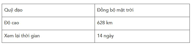
Key satellite specifications
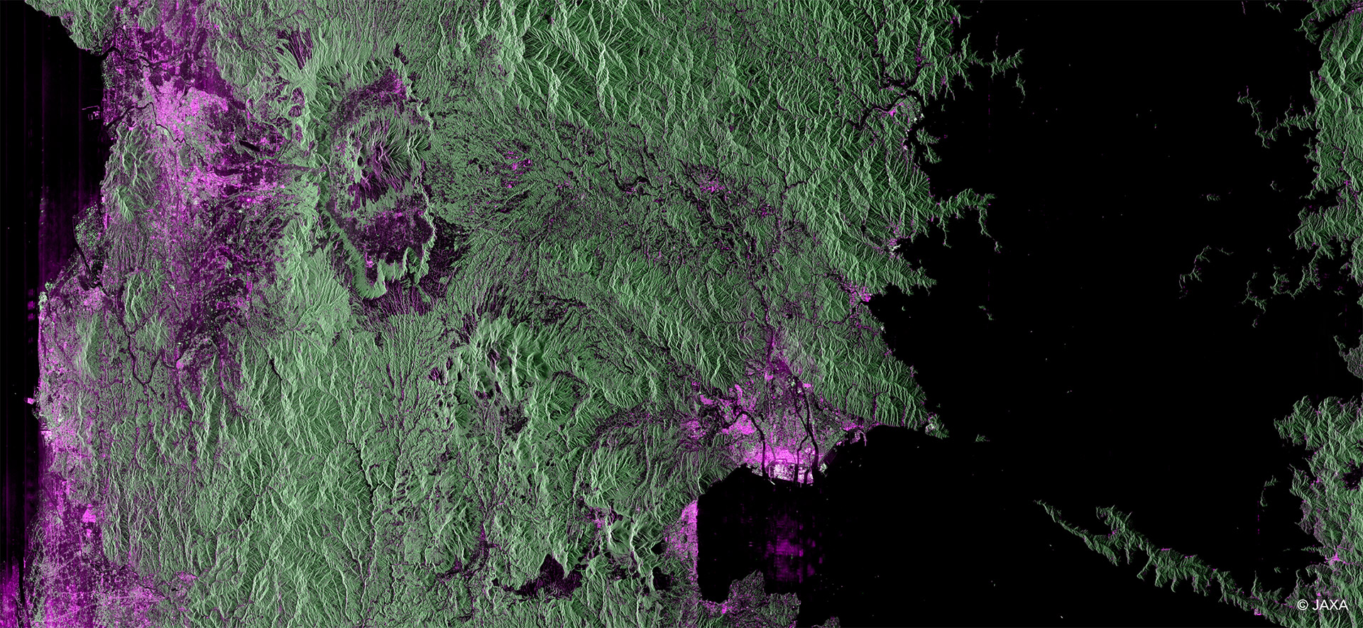
Land cover visualization through a color composite image,
acquired by ALOS-4 in April 2025, captures the Kyushu-Kumamoto area. Stretching from Kumamoto city center to the Aso caldera, this image demonstrates the ability to capture a vast 200km swath in a single pass. Through the color composite, the image clearly shows the contrast between vegetation (green) and urban areas (purple/pink), highlighting the satellite's power in distinguishing detailed land cover and terrain.
Observation Modes
PALSAR-3 (ALOS-4) observation modes offer three primary observation modes, allowing you to choose the ideal balance between resolution and observation area for your specific application.
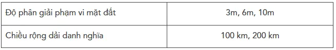
Strip Map (High Resolution)
This standard observation mode achieves an unprecedented combination of high resolution (down to 3m) and an ultra-wide scan range of up to 200km. This allows for detailed monitoring of large areas, significantly improving response times for disaster management and regional surveillance.

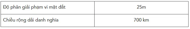
ScanSAR (Wide Area)
By beam scanning, ScanSAR mode achieves an ultra-wide observation range of up to 700km. This is ideal for wide-area mapping, such as sea ice monitoring, maritime activities, or assessing the extent of large-scale disasters like floods and wildfires.
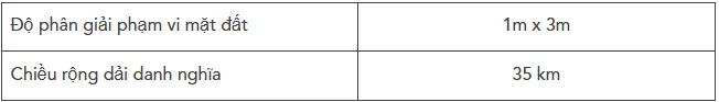
Spotlight
In this mode, the antenna beam is steered to focus on a specific, smaller target area for a longer duration. This achieves the highest possible resolution (1m x 3m), perfect for detailed site monitoring, infrastructure analysis, and target identification.
Technical Notes: The observable range is 1160 km both to the left and right (diagonally), corresponding to incidence angles from 8° to 70°. Observation in standard high-resolution mode includes right-side observation, a 200 km swath width, and incidence angles from 30° to 44°.


Can't find the product you're looking for??
Share your needs with suppliers and receive direct quotes using Arobid RFQ!
